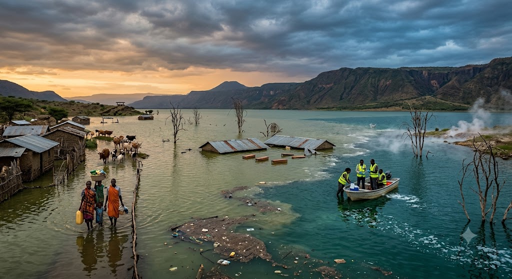
The rising waters of Lake Baringo and Lake Bogoria in Kenya’s Rift Valley represent one of the most visible and devastating climate crises in East Africa. Far from a temporary seasonal flood, this is a profound reshaping of the landscape that has forced communities into repeated displacement, swallowed critical infrastructure, and triggered a major ecological emergency.
Over the past decade and a half, Lake Baringo has swelled by roughly 50%, growing from 160 square kilometers to over 250 square kilometers. Villages like Loruk, Kampi Samaki, and Kokwa Island have seen homes, primary schools, and entire multi-million shilling safari lodges submerged under meters of water.
1. What Is Going On? The Science Behind the Phenomenon
The dramatic swelling of these lakes is driven by a complex cocktail of meteorological anomalies, environmental degradation, and deep-seated geology:
- The Climate Engine (Extreme Hydro-Climatic Shifts): Since 2010, the regional climate pattern has broken away from historic norms. In the catchments feeding the lakes, average annual rainfall has increased by 30% to 50%, and at specific weather stations like Marigat, total annual rainfall has more than doubled. Shorter, far more intense bursts of rain are dropping massive volumes of water directly into the basin.
- The Loss of the “Sponge Effect”: Decades of heavy overgrazing, deforestation, and unsustainable farming practices have stripped the surrounding highlands of their natural vegetation cover. When heavy rains hit, the bare soil cannot absorb or slow down the water. Instead, rainfall sheets off the hillsides rapidly, turning into aggressive runoff that empties into the lakes.
- Severe Basin Siltation: As that runoff rushes down the slopes, it strips away hundreds of tonnes of fertile topsoil per hectare every year. This immense load of debris and sediment settles directly on the lake beds. As the bottoms of the lakes fill up with mud, the basin becomes shallower, displacing the water and forcing it to spill outward across flat terrain. This sediment layer also “seals” the lake beds, hindering natural groundwater recharge and aquifer drainage.
- The Tectonic Element: Because both lakes sit inside the active East African Rift system, scientists continue to investigate whether deep-seated seismic shifts or changes in underground volcanic faults have altered subsurface groundwater flows or blocked historical subterranean outlets.
2. Where Is the Trend Headed? The Looming Collision
If current trends continue, the region faces an unprecedented ecological tipping point: the merging of the two lakes.
Historically separated by more than 20 kilometers, the expanding shorelines have shrunk that buffer zone significantly. Lake Bogoria is a hyper-saline, highly alkaline water body filled with hot springs and steaming geysers—the perfect habitat for microscopic algae that support millions of pink flamingos. Lake Baringo is a freshwater ecosystem crucial for local fishing, agriculture, and drinking water.
If Bogoria reaches its critical overflow spill point, its toxic, alkaline waters could pour through the lowlands directly into Lake Baringo.
The Catastrophe Scenario: An overflow would instantly shock Lake Baringo’s chemistry, causing its fish populations to collapse, wiping out local fishing livelihoods, and poisoning water supplies for hippos, crocodiles, and human settlements. Concurrently, the dilution of Lake Bogoria would destroy the fragile algae feeding the flamingos, decimating the area’s global tourism economy.
3. Possible Interventions: The Blueprint for Mitigation
Stopping a shifting landscape requires addressing land-use management as much as climate adaptation. Moving forward, several critical strategies are being deployed and proposed:
Landscape Restoration & Catchment Management
The most immediate way to slow the rising waters is to restore the basin’s natural “sponge effect”. This involves widespread reforestation and pasture reseeding to hold the soil together. Constructing terraced farmlands and silt-catching check dams across highland rivers can capture mud and rocks before they reach the lake basin, preventing further siltation.
Formal Relocation and Zoning
Local communities have expressed a willingness to move but need structured, government-backed support. Establishing permanent, planned resettlement schemes on safer, higher ground is essential to get families out of a cyclical cycle of flight.
Policy Actions and Climate Finance
Kenya’s Ministry of Environment and Climate Change launched an aggressive, multi-agency loss and damage assessment around the lakes. By quantifying the exact damage to infrastructure, schools, and biodiversity, the government aims to leverage international resources from the global Fund for Responding to Loss and Damage. Additionally, the county has established the Baringo County Climate Change Action Plan to scale early warning systems and solarize community water infrastructure.
Engineering and Hydrological Interventions
Large-scale international collaborations—such as a joint €14 million initiative funded by the European Union alongside development partners like GIZ and AICS—focus directly on engineering interventions. These projects look at implementing physical water-flow barriers, dynamic drainage management, and structural check dams to slow runoffs and protect critical public infrastructure like schools and roads from the advancing shorelines.
To get a clearer sense of the scale of this geographical shift, check out this video breakdown: Rift Valley lakes level rise coverage. This news report provides a direct visual look at the submerged schools, flooded farmlands, and the immediate humanitarian impact on families living along the shifting shores of Lakes Baringo and Bogoria.
Never Miss a Story: Join Our Newsletter